State Park Stickers this year are $24.00 for residents and $29.00
for non-residents
Daily Passes are $6.00 and $8.00
ORV Stickers are $16.25
ORV stickers may be purchased
on line as well as at all
MDNR Operation Service Centers.
Scramble Areas
The state of Michigan currently has 5 designated scramble areas
within which ORV's may be operated. A
scramble area is a "designated area" in which an ORV
operator is NOT restricted to the use of the existing trails or
pathways. The operator is able to travel wherever they wish, unless
of course the area is posted closed.
The designated scramble
areas are as follows: (listed from South to North)
The Mounds
200 acres.
Operated by: Genesee County Parks & RecreationThe
Mounds is located in Mt. Morris, MI. It is North East of Flint.
From I-75 North or South, Exit at Mt. Morris Road. Take Mt. Morris
Road ~ East ~ for about 6 miles. The Mounds will be on your left
hand side about 1/4 mile past Genesee Road.
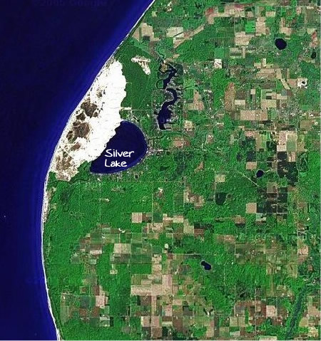
Silver Lake Sand Dunes
450 acres.
Operated by: The Michigan Department of Natural Resources Silver
Lake Sand Dunes is located in Mears, MI. It is approximately
80
miles Northwest of Grand Rapids. Visit Silver Lake Sand Dunes'
website at
silverlakesanddunes.com for information on campgrounds and hotels. www.michigandnr.com Dnr
Website
St. Helen Motorsport
Area 1,280 acres.
Operated by: The Michigan Department of Natural Resources, maintained
by volunteers.The
St. Helen Motorsport area is located in St. Helen, MI. St. Helen
is just off of exit 222 on I-75. It is about 20 miles due East
of Houghton Lake.
Bull Gap
60 acres for the hill climb area and 115 miles of trails, operated
by the US Forest Service.Bull
Gap is located in the Mio, MI area. Mio is about 30 miles due
East of Grayling and about 30 miles due North of West Branch.
Black Lake Recreation
Area
400+ acres.
Operated by the DNR, maintained by volunteers.
Black Lake is
located about 20 miles East of Indian River, MI. Exit 310 on I-75.
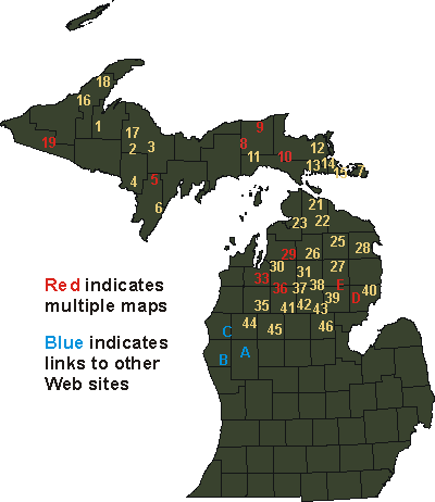
ORV/ATV
Trail Maps
To view a map, select a file from the map or list (average file
size 318KB).
Pause the pointer over a number on the map to view the trail name.